


For more information regarding the value of a property, please contact us for a free consultation.
TBD Moose Ridge Dr. Orofino, ID 83544
Want to know what your home might be worth? Contact us for a FREE valuation!

Our team is ready to help you sell your home for the highest possible price ASAP
Key Details
Property Type Vacant Land
Sub Type Unimproved Land
Listing Status Sold
Purchase Type For Sale
Subdivision 0 Not Applic.
MLS Listing ID 98873538
Sold Date 08/01/23
HOA Y/N No
Originating Board IMLS 2
Annual Tax Amount $123
Tax Year 2020
Lot Size 20.450 Acres
Acres 20.45
Property Sub-Type Unimproved Land
Property Description
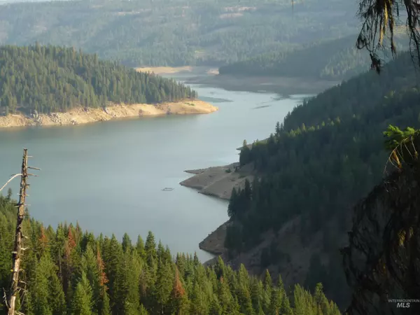
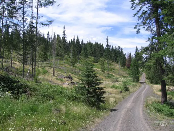
20.45 Acres of Prime, Forested Dworshak Reservoir View Property with minimal CC&R's. OWNER WILL CARRY WITH 20% DOWN, 5% INTEREST, 30 YR AMMORTIZATION, BALLON IN 3 YEARS PER AGREEABLE TERMS OAC. Located in a Quiet, Rural, Forested setting but just 8 Miles to Services in Orofino & 5 Mi. to Merry's Bay Recreation Area. A Sportsman's Paradise... Moose, Elk, Whitetail, Turkey & Grouse frequently on property. Dworshak Reservoir has Trophy Bass & Clearwater River is nearby for Steelhead Fishing. Property borders Corp of Engineers Land Reserve around Reservoir for access to Dworshak Reservoir. At least 2 roads access property in different areas. Electric is nearby. Property consists of a 19.05 & a 1.40 acre parcel. Potential for Additional Building Lots & has had preliminary survey work done, needs wider road & County Approval to formalize. Check with Clearwater Co. P&Z. See Docs Tab for lots more information. Location is about 50 Miles NE of Lewiston ID. Some photos are from adjacent property.
Location
State ID
County Clearwater
Area Clearwater County - 2095
Zoning Timber-Productivity
Direction 7.5 Miles North of Orofino left off Canyon Creek Rd left on Cedar Ridge Dr. to Indian Creek Rd to Moose Ridge Dr. Please note that Aldrich Lane on some maps is actually Moose Ridge Dr. *See Docs Tab for specific directions!! Call Listing Agent if you need help!
Interior
Fireplace No
Exterior
Fence None
Community Features Recreational, Single Family
Utilities Available Electricity Available, Natural Gas Not Available
Street Surface Gravel
Building
Lot Description 20 Acres - 40 Acres, Level, Rolling Slope, Sloped, Solar Potential, Surveyed, Views, Wooded, Borders Public Owned Land, Canyon Rim
Faces 7.5 Miles North of Orofino left off Canyon Creek Rd left on Cedar Ridge Dr. to Indian Creek Rd to Moose Ridge Dr. Please note that Aldrich Lane on some maps is actually Moose Ridge Dr. *See Docs Tab for specific directions!! Call Listing Agent if you need help!
Sewer Septic-Proposed
Water Proposed Well
New Construction No
Schools
Elementary Schools Orofino Elementary
High Schools Orofino High School
School District Joint School District #171 (Orofino)
Others
Tax ID RP37N01E247202A (19.05 AC)
Ownership Fee Simple
Acceptable Financing Cash, Conventional, Owner Will Carry
Listing Terms Cash, Conventional, Owner Will Carry
Read Less

© 2025 Intermountain Multiple Listing Service, Inc. All rights reserved.